A cold hike in Nescopeck State Park.

It was windy and cold, 12 degrees, but the sunshine and deep blue skies made for a nice hike in the Nescopeck State Park. There is about 8 inches of snow on the ground so wasn’t easy walking. saw a few cross country skiers on the way. Lake Francis was frozen solid. Winter isn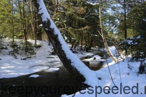 ‘t my favorite season but it was still nice to be outside. I tried to include a link to my Flicker account but this is my first “official” blog post so hope it works. Please free to comment or make suggestions. https://www.flickr.com/photos/green_ridge_adventures/sets/72157648243997504/
Nice Job Frank! Will be visiting often.
Thanks Shari.It took me awhile to figure out how to reply. I really am not good at this but I am getting better, very slowly. Hard to teach an old dog new tricks. 🙂 Looking forward to your comments.
love following some blogs, will add yours to my list. I always enjoy your photography. Good luck!
Thanks so much Pam, i hope I can keep your attention.
206 N. Third St.
Great viewing I have been to a lot of places through you
Thanks Nancy I really appreciate and love to have you come along.
Should you decide to get a full subscription to Critter Map Software . Or, I like and use, BackCountry Navigator Pro. To be had at Amazon Prime for an overview.
It could provide your audience with a detailed map of your trek. Mark interesting waypoints to peak the audience and our five senses. Furthermore, its fun to Geo Sync a treasure chest, and invite others to find it.
By providing coordinates to project to the next local adventure. Then invite a picture to be shared at the sponsored coordinate should the author choose to include one.
There are many other land navigation programs. These come to mind. I have used both since their inception and will stand by the accuracy in them. Along with a detailed library of tiles in all parts of the this vast USA that other enthusiasts share. It may be a way to have others experience first hand what you enjoy . Our local outdoors.
Cool. I was looking for a better map program. I really don’t like the one I use on my IPhone. I will check them out for sure. Thanks for the help.
Very nice, Frank. The picture shows up much better than on Facebook.
Thanks Tammy, they do but wondering if the are to large for some folks to upload. Did you have a problem?